
Paul Thomas and I were sitting in a booth eating dinner at the Four Seasons restaurant on Lone Pine's hot corner. Lone Pine, California is the "Gateway to Mt. Whitney" and at this time of year — early June — Lone Pine is busy with fly fishermen, those eager to hike to the highest spot in the lower 48, and PCT through hikers down for resupply and maybe their first hot baths after walking 750 miles.
Two men about my age — late 50s — occupied the booth adjacent to ours. I overheard one of them ask, "So what about tomorrow? Whitney Portal?"
"That, or Horseshoe Meadows," said the other.
Me, big buttinsky busybody, craned my head over and asked, "You guys cyclists?" Yup. "Got Summerson's book on climbing?" Yup.
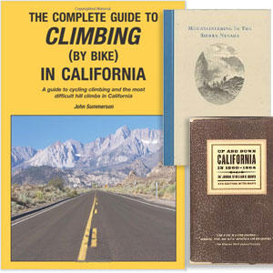
This is, now, the other category of visitor to Lone Pine: ascent bagger, of the cycling kind. I wrote about the California edition of John Summerson's The Complete Guide to Climbing (By Bike) back in 2010 and the original national volume in 2009, and it remains the fulcrum of a cycling cult. The national book describes the 144 toughest climbs you can do on a bike in the United States, and Mr. Summerson has augmented this with regional editions, one of which is California. In this book you get a lot of climbs not in the national book (there are editions for Utah, Colorado and the Southeast, where Mr. Summerson lives).
These books describe the climbs, where they begin and end, elevation gain, with lists of the steepest 1, 5 and 10 mile sections, climbs with the most total elevation, and each climb gets a score based on an algorithm that quantifies difficulty.
"Do you have Summerson's new California edition?" I asked the gentlemen at the next table. No? They drove over to our motel after dinner and I gifted them mine, as one of these gentlemen was from Malibu and the new California book has all the Santa Monica Mountain climbs, as well as an exhaustive list of all the climbs in the Tehachapis and Southern Sierras.
This book written about here is the updated version of the California edition.
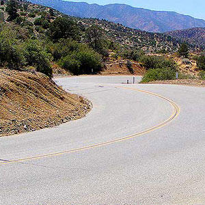
In my opinion, the staging areas for the best climbing in California — and maybe this is provincial thinking but also in the United States — are Kernville, Springville, California Hot Springs and Lone Pine, all one side or the other of the Southern Sierra Nevada mountain range. These towns are America's versions of Canazei and Cortina in Italy's Dolomites, if you're just talking about staging areas for great epic road ascents. For culture and night life I'd much rather be in ritzy Cortina than funky Lone Pine or Kernville, but the Dolomites and its climbs — fun as they are, with perfectly paved roads built like go-cart tracks — for the most part cannot compare in difficulty to the climbs of the Eastern and Southern Sierras. One of the gentlemen in the next booth over chose here, the Eastern Sierra, to prep for his upcoming Craft Bike Transalp race.

The formulaic athlete will find no use for this book or the notion of the ascents this book chronicles. But the intrepid athlete will find this book something between a field guide and a devotional. It sits by my bedside.
These two fellows at the next booth over climbed from Independence to Onion Valley earlier in the day, 3700' to 9200' over a 12.5 miles, the last 10 of which is the steepest 10-mile stretch of pavement in the United States (8.3°). Nasty. Paul and I climbed Nine Mile Grade earlier that day and Whitney Portal in the afternoon. We "peeled the Onion," as Paul puts it, the following morning and then in the afternoon Paul took on mighty Horseshoe Meadows — which I think is harder than Onion Valley.
Me, I drove to the top of 10,000' Horseshoe Meadows road and ran for an hour while I waited for Paul. A run at that altitude might sound arduous, but it is nothing compared to ascending that beast on a bike, with about 6300 total vertical feet gained in 20 miles.
On our last day in the Eastern Sierras we finished off with Glacier Lodge, out of Big Pine (image above is me at the Glacier Lodge pack station), and this climb always surprises us with its difficulty, probably because we manage to end our climbing vacations with this ascent.
This finished an 8-day stretch for Paul that netted 40,000 vertical feet, while my puny 13,000 feet over 4 days was about enough for me.
As we descended Glacier Lodge we saw three cyclists riding up. Used to be you'd never see another cyclist climbing these East Sierran beasts, which dwarf in size and difficulty most of the famous climbs we read about in grand tour racing. Not now. Ascent bagging, Mr. Summerson's books in tow, probably with Strava as an adjunct, is more and more a thing to do for serious road bike enthusiasts.
The only issue I take with Mr. Summerson, and it's mild, is the choice of some of his starting and ending landmarks. He appears to want to imbue the climb with the greatest vertical possible. So, Horseshoe Meadows begins with a climb out of Lubken Canyon Road and this adds a few vertical feet. But the most scenic route by far is up Tuttle Creek Road and this 9 minute video should convince you that this is a road made for cycling (especially minute-4 through minute-7 with the High Sierras as a backdrop).
Likewise, the climb out my own backyard, Big Pines Highway, may now become a Tour of California staple, with this year's Stage 6 ending atop this climb — the second time the ATOC has scaled this road. The proper way to ascend this is the way ATOC does it, from Valyermo (Slowtwitch global headquarters), at the intersection of Big Pines Highway and Big Rock Creek Road. I think in time Mr. Summerson's future editions may continue to benefit from the input from his fans and enthusiasts, such input including the way readers ride their local ascents. I'd like to see future editions slightly alter the description of some of the climbs to match the way they are traditionally ridden.
You'll find both the national and all the regional books here at the author's site, along with links to Amazon and Barnes and Noble.