In a normal year, the summer solstice would mark the heat up of the multisport racing calendar. As we all know well enough by now, 2020 is not a normal year. This weekend should mark the return of IRONMAN 70.3 racing to the U.S. in Lubbock. Many, however, are uncomfortable with the idea of returning to racing. There is a thread in our Reader Forum currently debating what it would take for you to return to racing, with many replies of “nothing until there is a vaccine or treatment protocol.”
So, what are we to do? Although many of us thrive on simply the process and lifestyle of training, we also want to build up to something. What can stoke the fire, bring out the nervous energy that’s typical on race morning, and push you to your personal limits?

It’s about finding your adventure. What makes racing exciting isn’t just the push of you against the clock. It’s your surroundings. It’s your like-minded friends. And it’s the stories that come out of the challenge that we live for: the “lightning year” at IRONMAN Lake Placid; the “Run for the Hoses” Boston Marathon; the snow during IRONMAN Lake Tahoe; the shelter-in-place thunderstorm during IRONMAN Texas. The most challenging conditions and courses bring about the best stories.
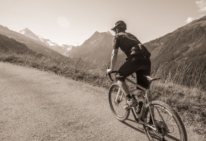
This is the story about one of those types of adventures -- taking to the mountains of Vermont for an epic day of bike riding across four of Vermont’s famed Gaps.
The Gaps
What are dubbed “notches” in New Hampshire or “passes” in the West are called “gaps” in Vermont. The six Gaps all are located in central Vermont, with a 25 mile span of State Route 100 providing the connection between them, with four to the west and two to the east.

Almost all of the Gaps are named for the towns that they are located in or bridge to: Brandon, Middlebury, Roxbury, Rochester, and Lincoln. The lone exception, the northernmost App Gap, is noteworthy for also being home to famed ski area Mad River Glen. Although none of the climbs feature more than 1500 feet, they are steep; in fact, Lincoln Gap features the steepest paved mile in the United States with an unrelenting 1.2 mile stretch at 15% grade.
There are generally two routes that cyclists will take: the full 130+ mile six gaps ride, or the abbreviated 106 mile four gaps that hits the eastern slopes of Brandon, Middlebury, Lincoln, and App Gaps.
The Preparation
The idea for this grand adventure was hatched with a simple text exchange between myself and Doug MacLean about a month ago. We decided we’d wind up parking in Rochester, VT near the southern junction of 100 and 73; this is where the trip up Brandon Gap begins. We opted for the four gap ride as we were both rookies to linking them together and because this would also be the longest ride of the year for us both by far.
From an equipment perspective, I opted for my gravel rig: a disc brake Parlee Chebacco with Shimano GRX and DT Swiss wheels. This gave me a nearly 1:1 climbing ratio for the steepest bits, enough range for the flats, and most importantly easily modulated braking for the descents. However, I’d last ridden this bike as a cyclocross rig, and so needed to swap over tires to something more road palatable. I wound up moving to Schwalbe’s Pro One tubeless, in 30c. Doug, meanwhile, tried the adventure on his Litespeed with a 55/42 chainring and a 12-28 cassette.

I mapped out the route and plugged it into my Suunto 9 through their mobile app; the only frustrating part of this experience was that it would not follow Lincoln Gap Road for navigation. As it turns out, though, this is common across many mapping tools, likely due to the fact that the road is closed in winters.
The Ride
We headed north from my house straddling the Vermont-New Hampshire border early, as forecasts were predicting the hottest day of the year to date and the strong potential for storms in the afternoon. Drainage on these mountain roads is less than ideal, and having hydroplaned on my bike previously along Route 100, we’d want to avoid storms if we could. A brief pit stop for coffee before heading onto the highway was our only hiccup.
Arriving to the Rochester parking lot to meet our third rider John Wilson, we discovered that we were not alone; a bunch of fellow northern New England cyclists were parking up as well for their six gap ride. We let them roll out first as we knew that their pace would likely be spicy out of the gate, and we got wheels down just before 8 AM.
We headed out route 73 to hit the first and least difficult gap, Brandon. Featuring a gradual climb ranging from 6 to 8 percent and smooth roads, it was an excellent warm-up. Towards the top there is a scenic overlook of Mount Horrid to the north; depending on how you’re feeling on Brandon, horrid could be an expectation of your mood later in the day. The descent here is also with good pavement and gentle sweeping turns; it’s an easy place to pick up speed.
Upon arrival to the village of Forest Dale, we took a hard right onto Route 53 and begin the trip northbound to attack Middlebury. Along the way, Doug’s crankset nearly fell off, which he was able to band-aid together. This experience came in handy, too, as we discovered a stranded rider with much the same problem and was able to get his crank back on his bike for his trip home.

We continued along our journey, using my Suunto as the navigation tool. Here’s one of our errors! I did not realize, while mapping out the route, that some of the roads I had selected (done to knock out a couple of miles and a few hundred feet of climbing) were some of the harshest gravel I've ever been on. Thankfully, the Schwalbe Pro One’s handled this curveball with aplomb; at 68-70 PSI, they smoothed out much of the washboard and still provided plenty of pace on the road.
Rejoining the pavement on Route 125, we made our first convenience store stop of the day to refill bottles. Don’t forget your masks! Most places in Vermont will not allow you in the door without them, and it’s easy enough to carry in your jersey baggy (along with your cash, driver’s license, and cell phone). Back onboard, we passed Middlebury College’s Bread Loaf campus to begin the climb in earnest. It’s a sustained 8% climb, with some pitches giving you a warning of what’s to come on Lincoln at 15%. This was the first real test of the day, with plenty of sun exposure also bringing the heat. You also pass your first ski area of the day, with Middlebury’s Snow Bowl on your right near the top of the climb.

A speedy, sweeping descent brings you back to Route 100 and yet another opportunity to refill your bottles. Hopping north on 100 brings you through Granville Gulf. It’s not a Gap, but there is some climbing here to be done; if you don’t feel well here, it may be best to leave Lincoln and App for another day. Alder Meadow Brook provides a cooling effect, and Moss Glen Falls on your left are stunning. Before too long, though, Lincoln Gap Road approaches on your left.
It’s a short four miles from Route 100 to the top of Lincoln Gap, which is essentially divided into two climbs. You begin as soon as you turn off Route 100; it’s roughly equivalent to what you faced on Middlebury Gap in terms of pitch. Thankfully, the road flattens out as it turns to dirt. Avoid the urge to go low cadence here; you’re going to need that muscle strength for what comes as soon as you hit the pavement again. Once you’re on pavement, the real work begins.
Not only is it a sustained 15% average gradient to the top from here, but it reaches a maximum of 24%. You may paperboy. Doug ran out of gears and was full-out stopped. I dropped my sunglasses and had to stop, go downhill to remount, and circle back up. John was the Energizer Bunny and kept grinding to the top, the only one of us not to need to put a foot down. Sweat came from places I didn’t know you could sweat from. Finally, mercifully, the top arrives with a sighting of the Long Trail.

The descent off of Lincoln is quite technical. It’s narrow, twisty, and transitions from pavement to gravel and back again. A delicate touch is needed here. Tire selection can make a world of difference in experience; John and I on wider tires and lower pressures had a significantly better time coming down than Doug did. Soon we were in Lincoln proper and able to refuel again. It was our first of many real sugar Cokes purchased on this day.
Re-mounting, we headed toward Jerusalem proper via Quaker Street and Downingville Road. This section was exposed, with no wind and plenty of dust being kicked up from the dry gravel and dirt. It hasn’t rained in the northeast much over the last few weeks, and it showed here. After what felt like forever, we re-joined pavement and Route 17 to begin App Gap.
App Gap is deceivingly difficult. It becomes progressively steeper as you get further into the climb. Because App Gap is frequently used in the Green Mountain Stage Race, you can use the KOM markings on the pavement to denote how much further you have to go. The markings start with roughly 3K remaining in the ride, with the toughest part of the climb in the final 500 meters as it ramps to 24% at the end. A parking area on the left gives you a tremendous view to the north and west to celebrate the end of the toughest climbing.

The descent off of App Gap features some switchbacks as you make your way to Mad River Glen’s parking lot. The famed single-chair is right there on your right as you sweep left. Otherwise, it is relatively smooth sailing down to Waitsfield to re-join Route 100 and take the 25 mile journey back to where you started in Rochester. Make no mistake: this is an incredibly difficult day in the saddle, and by the time it was over I didn’t want to see my bike again for weeks.
Of course, a text chain started earlier this week. We’ll be hitting all six gaps next month.